


Drone Surveying in Construction: Simple, Effective, and Cost-Efficient
Drones simplify construction surveying with just a GPS base/rover and a drone. Affordable, reliable data without the complexity.


Structurally Correct
The most progressive contractors are moving to 3D modeling for their structural excavations, just like they use a 3D surface model to grade

Single Point GPS Site Control: How to Ensure Accuracy & Avoid Errors
Avoid common pitfalls with Single Point GPS site control—learn to ensure stable, accurate results and avoid costly mistakes in grading.


Site Control - Principle 4
You hired the project Engineer to place your control, you surrounded the site with points and shot in more than five control points. What c
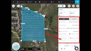
Quantum Flight Pack - Flight Planning Video
Supplement your GPS machine control system with Quantum's Flight Pack drone system. In this video you will learn how to plan a topograp


Site Control - Principle 3
Setting up your machine control system requires the use of site control points. The number of them you calibrate to is important to the pro


Site Control - Principle 2
Let's imagine your project is drawn on a piece of paper and you have to place it on a globe. To get the paper - your project - to confo

Engineer's Surface - Worth The Risk???
As GPS machine control continues to become more commonly used, engineers are readily giving out digital files. Some engineers in addition t


Site Control - Principle 1
Why hire the design Engineer's surveyor, you ask? There may be someone that will do it cheaper, faster or you want to help out your bro


Get Your 3D Grading Under Control
Poor site control is one of the most common (and avoidable) problems encountered by Quantum's clients. Improper site control leads to a


